


Hiking Dude Blog
2025 - Aug Jul
2024 2023 2022 2021 2020 2019 2018 2017 2016 2015 2014 2013 2012 2011
07/27/2017
Day 14: Thumbs Up
 I walked 11400 steps on the trail today.
I traveled about 5 miles today.
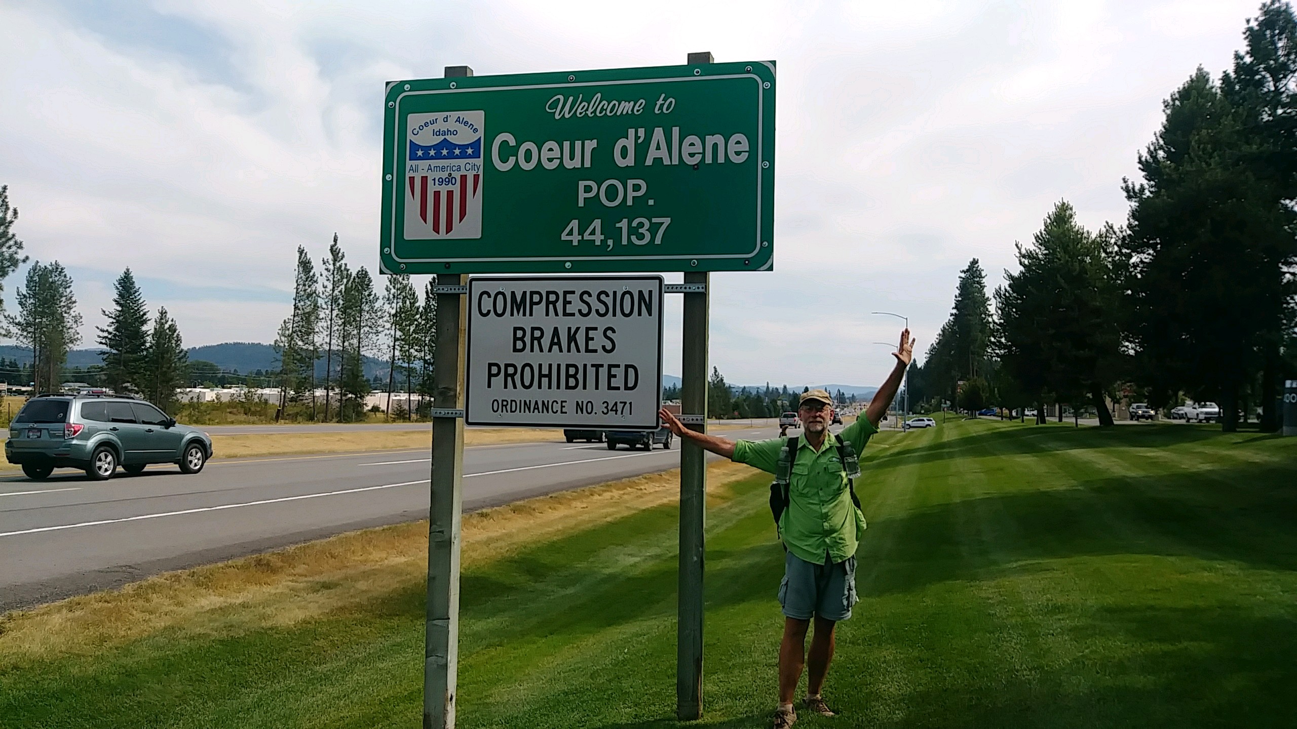
7/26/17 We actually walked about 18 miles today, but only the first 5 were on the PNT. The rest were along us95 trying to get from the trail crossing about 15 miles north of Bonner's Ferry down to Coeur d'Alene about 90 miles south. We will be off trail for 10 days working at Camp Lutherhaven. Josh worked here for 2 summers and I worked here 37 years ago. This is where my wife and I met and its our 30th anniversary next week. She is driving out here with a friend to be here this weekend for a dutch oven cooking and wine tasting ladies event. I've been asked to present about cooking so that should be fun. Next week, we're just doing whatever is needed. Anyway, we made it to CDA but it was a fun, long day getting here. Up at our usual time but in a new time zone so we were actually starting wire early. No water except that which we had carried over the mountain yesterday. We walked the miles on dirt road down to the busy us95 and headed south. We hiked on for two hours as cars zoomed past. I used my 'To Town' sign and cars zoomed past. We stuck out our thumbs and cars zoomed past... Continue...
Leave Comment
Posted: 07/27/2017
Posted: 07/27/2017
08/04/2017
Done Hiking Today
I finished hiking for today. You can check out my current location on the map and I'll post about my day when I am in coverage.
Leave Comment
Posted: 08/04/2017
Posted: 08/04/2017
08/06/2017
Done Hiking Today
I finished hiking for today. You can check out my current location on the map and I'll post about my day when I am in coverage.
Leave Comment
Posted: 08/06/2017
Posted: 08/06/2017
Done Hiking Today
I finished hiking for today. You can check out my current location on the map and I'll post about my day when I am in coverage.
Leave Comment
Posted: 08/06/2017
Posted: 08/06/2017
08/07/2017
Done Hiking Today
I finished hiking for today. You can check out my current location on the map and I'll post about my day when I am in coverage.
Leave Comment
Posted: 08/07/2017
Posted: 08/07/2017
08/08/2017
Done Hiking Today
I finished hiking for today. You can check out my current location on the map and I'll post about my day when I am in coverage.
Leave Comment
Posted: 08/08/2017
Posted: 08/08/2017
08/09/2017
Done Hiking Today
I finished hiking for today. You can check out my current location on the map and I'll post about my day when I am in coverage.
Leave Comment
Posted: 08/09/2017
Posted: 08/09/2017
Day 15: Back on Trail
 I walked 12640 steps on the trail today.
I traveled about 5 miles today.
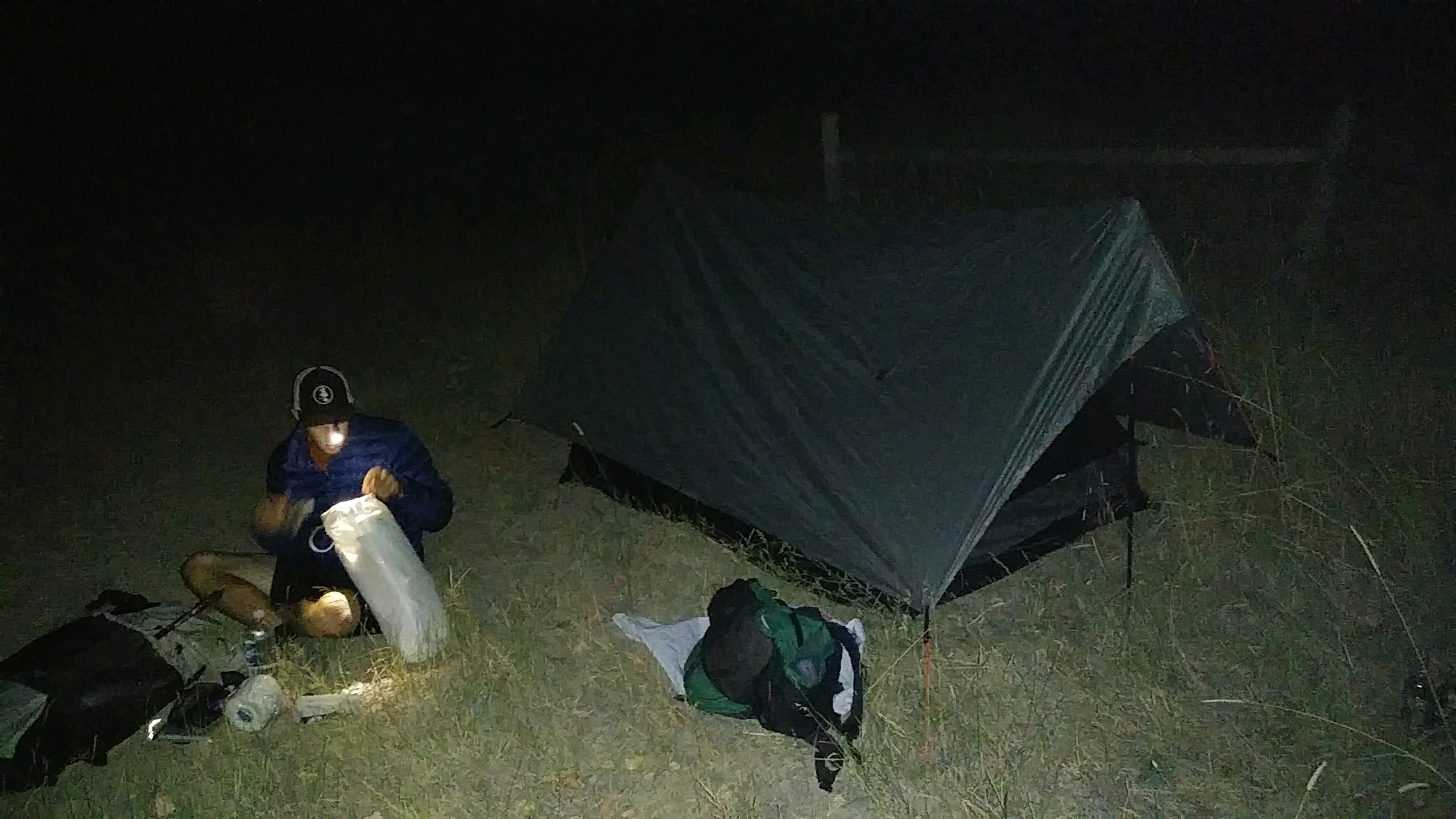
8/4/17 Josh's friend drove us from Lutherhaven to our trail head above Bonner's Ferry late in the evening and we just road walked to the Kootenai River levy and threw down our tent. Waved to a few farmers as we walked but that was it. The sun was blood red as it set from all the forest fire smoke and the nearly full moon rose a bright orange.
Leave Comment
Posted: 08/09/2017
Posted: 08/09/2017
Day 16: Cool and Clear
 I walked 61700 steps on the trail today.
I traveled about 24 miles today.
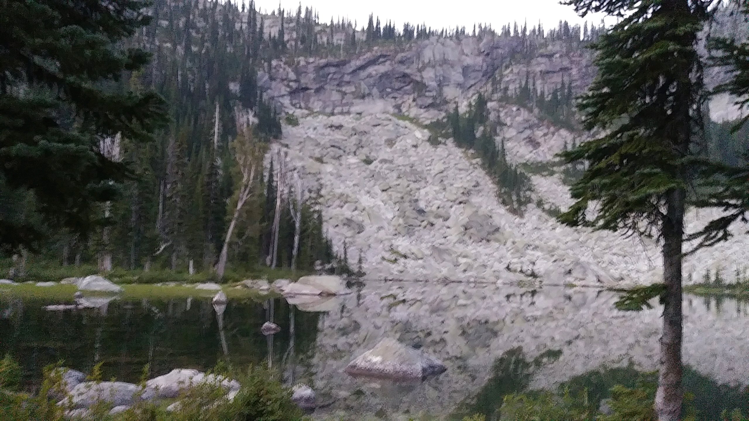
8/5/17 We had the option of hiking the PNT route or an alternate today. The choice was between a 17 mile climb up a burned out, bone dry ridge or a 24 mile climb along a creek in a shaded forest - we took the longer route and that made all the difference. From the Kootenai River at 1700 feet, we hiked uphill all day to Pyramid Pass at 6700 feet before dropping down a bit to camp at Pyramid Lake. So, today was a long mile+ of elevation gain but the campsite was beautiful. Right by a high alpine lake with trout jumping and a 700 foot rock wall as a backdrop was a perfect place for our little shelter. The forest was a nice cedar and pine refuge from the heat of the day and we had no problem with finding water. We met one couple that was hiking the trail for two days, and a large group of about 10 people had filled the main campsite at the lake. The smoke wasn't too bad today and the moon and stars were very nice in the night.
Leave Comment
Posted: 08/09/2017
Posted: 08/09/2017
Day 17: Bushwhacks, Eagles, and Slides
 I walked 46800 steps on the trail today.
I traveled about 14 miles today.
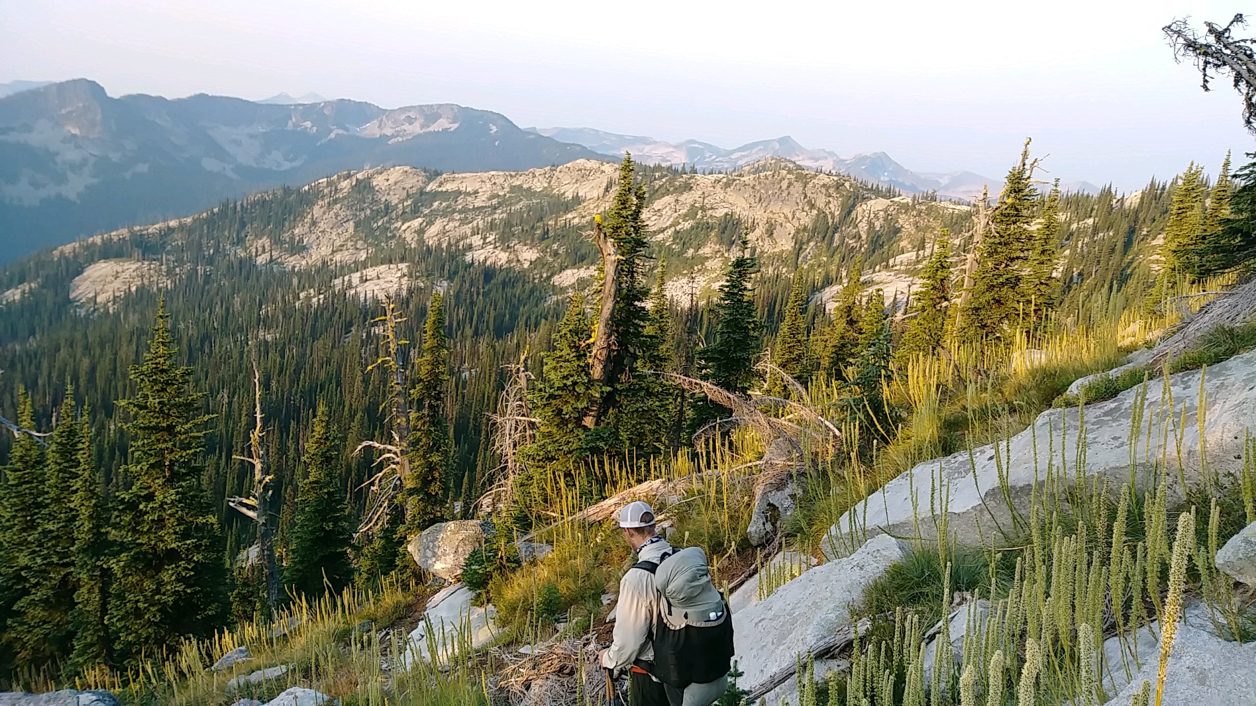
8/6/17 Our day started with a 600ft climb up from pyramid lake to the end of the trail - literally. From there we navigated 6 miles with no real trail - it was very slow difficult going but a wonderful experience! Except for the fact that Josh got stung by some nasty bee or wasp on his leg. This is Josh lagging the way with no trail to follow. At the end, we came to a creek that flowed over solid rock, making a natural water slide. We decided to spend an extra 45 minutes playing here because it was so cool. As we hiked down a couple miles and neared the trailhead, we encountered dozens of people hiking up. It turns out that there are some VERY popular water slides lower on the creek. Refreshed from our swim, our afternoon entailed a 3300ft climb up Lookout Mountain - on a dusty old overgrown atv track on the hot south side with little shade. I sweated the whole way but we were fortunate to have 3 nice water sources on the way up so staying hydrated was not a problem. Also, halfway up the climb a juvenile eagle took off from the path no more than 10 yards in front of us. He flew right past us and sailed down the trail - very cool! Every day my shirt and pants are soaked with sweat. Today, we reached our campsite so late they had no time to dry. I'll try drying them as we hike tomorrow. Our camp was at a small lake at the source of Lucky Creek. We were lucky to find it. Our maps, our app, and our data book had no help in figuring out where the trail was and how to find the camp. I was just lucky (after spending a lot of time on dead ends) to notice a small side trail and give it a try. The location was a beautiful end to a great day of hiking.
Leave Comment
Posted: 08/09/2017
Posted: 08/09/2017
Day 18: Washington
 I walked 57300 steps on the trail today.
I traveled about 27 miles today.
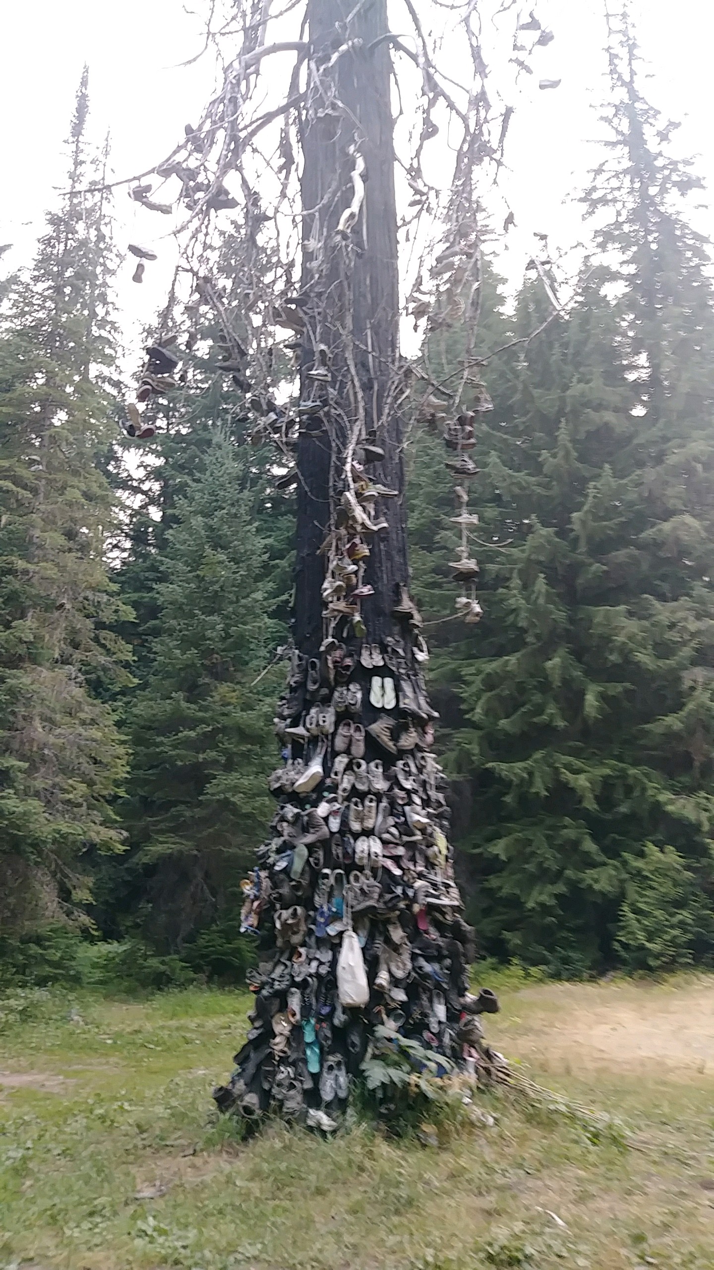
8/7/17 To make up for the last two days of big climbs, today was almost all downhill or gently rising. The day started with snacking on huckleberries as we walked and spooked two elk off the trail. Early on, our trail crossed a road and stopped. Our app, map, and book made no note of walking the road or tricky turn so (after searching up and down the road for any clues) we plunged down the steep forested hillside knowing we would eventually run into the trail on a road below us. It worked and only cost a few scratches. The rest of the trail was very nice and mellow, passing along Priest Lake and through a huge old cedar forest. To keep up with Josh, I got stung in the back of my head - man that hurts! We met a trail crew putting in a boardwalk. We also met a couple on the shore of Priest Lake and chatted with them awhile. Now, we are on the roadwalk from Hades. There is a large fire burning that has closed the PNT and its alternate routes. So, we are doing some 50 or 60 mile detour to reach Metaline Falls. The roads are all dust and there has been plenty of cough cough traffic. One very nice logger slowed way down and said hi as he passed. Around 1pm we crossed a wonderful looking river so we stopped for about 45 minutes to eat, get water, skip rocks and rinse off. It was great! But cold! A very strange man stopped his pickup on the bridge and began a conversation with us about how the world is pretty much going down the toilet. He finally left. As our feet were dragging and my knees were aching, we found a spot to camp. Right on the creek across from the dusty road and there is the strangest Shoe Tree here. For some reason, there are hundreds of shoes thrown into an old burned cedar tree. Weird. The smoke is very bad and bits of ash rained on us at times. And, we crossed into Washington this afternoon!
Leave Comment
Posted: 08/09/2017
Posted: 08/09/2017
Older Posts Newer Posts
Find more Hiking Resources at www.HikingDude.com
Follow Me
Recent Comments