Hiking Dude Blog
2025 2024 2023 2022 2021 2020 2019 2018 2017
2016 - Dec Nov Oct Aug Jul Jun May Apr Mar Feb Jan
2015 2014 2013 2012 2011
08/31/2016
Hops, Not Hiking

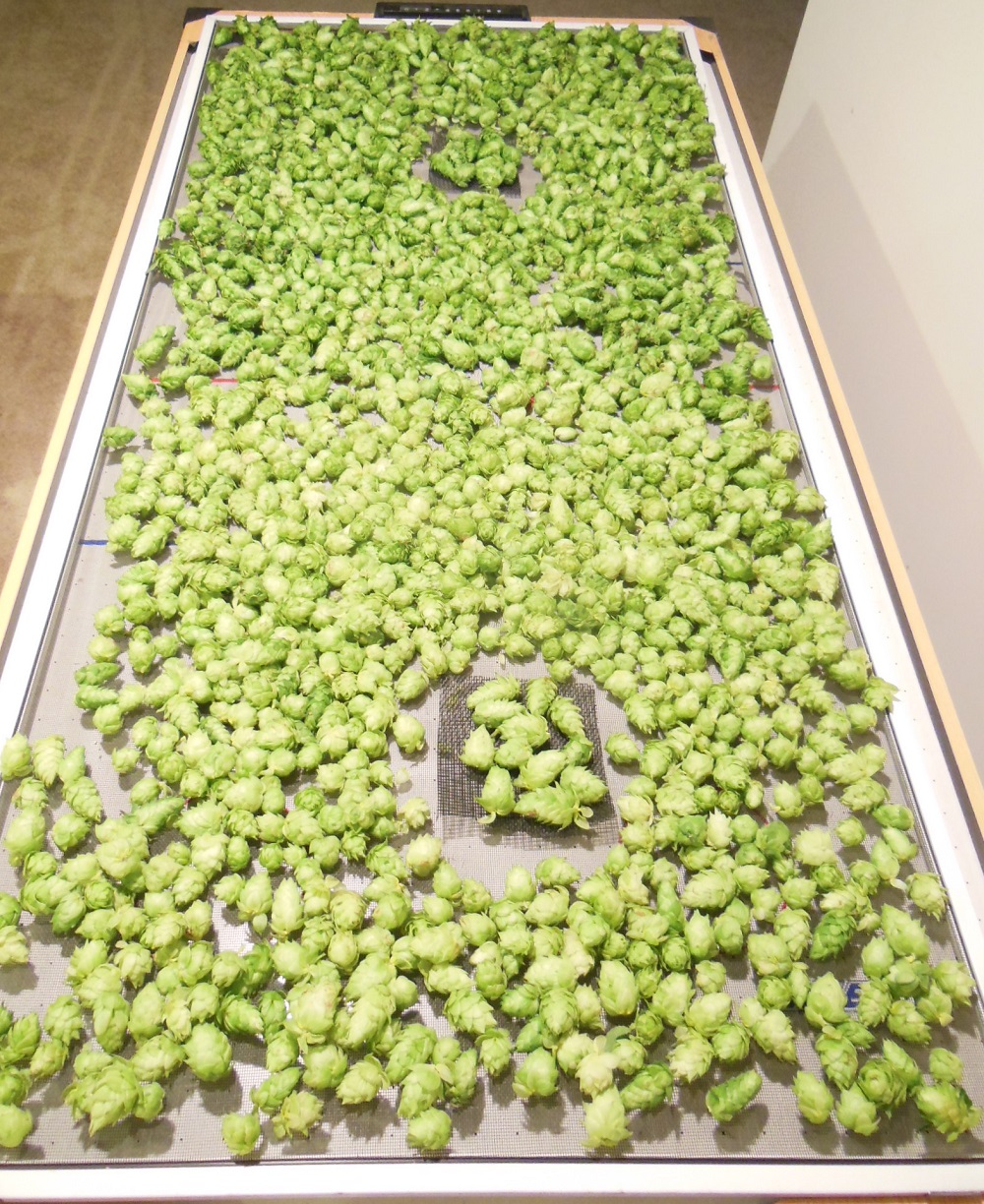
 Besides hiking, I also homebrew beer. My wife wasn't using our very small garden plot this year, so I grew four hop plants just to see what would happen and today was the surprise harvest day. These are all the hops I harvested from my small garden. Tonight, they are laying on a screen on an old air hockey table where they will hopefully dry over the next day so I can use them in my next batch of beer.
In 5 short months, I've learned a ton about hop farming - and there's still tons and tons more I don't know, but that will make it fun to continue on learning. For example, just the terms are weird - a bine is a hop plant that normally would be called a vine, the hop plant that gets planted in the ground is called a rhizome, and the part you harvest is a cone. That screen has about 2 pounds of cones on it.

 But, I want to let you know how I spent my last day with my hop farm.
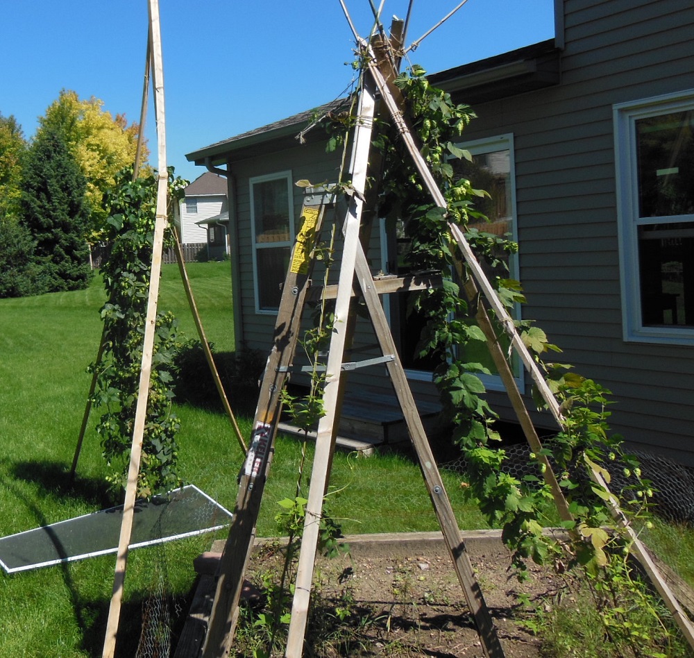
 I planted four rhizomes way back in April - two Cascade hops and two Nugget hops. I built a 7-foot pyramid trellis for them to climb and, as they quickly sprouted and reached towards the sun, they worked their way to the top. All four bines survived, grew, and were healthy. I kept their small area weed-free and life was good.
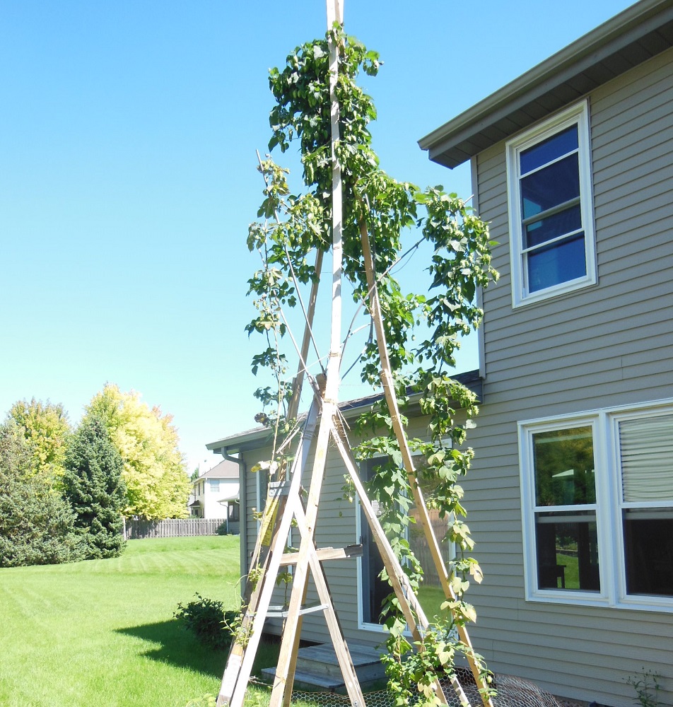
But, those bines wouldn't stop growing. I finally had to accept the fact that hops really do grow to 20 feet high. I lashed together a taller three-poled trellis and up they climbed. This is the final growth that I started harvesting today. The bines reached the top, wrapped around, and basically made a big knot of hops at the top. Hey, it was my first year and I just wanted to grow hops.

 I found out today was harvest day because I tested a dozen cones to find their moisture content. If it's under abour 78%, it's time to harvest. I weighed them, then microwaved them to evaporate off all the moisture and weighed them again - moisture was only 70% so they were drying out and I didn't want them to go bad on the trellis.
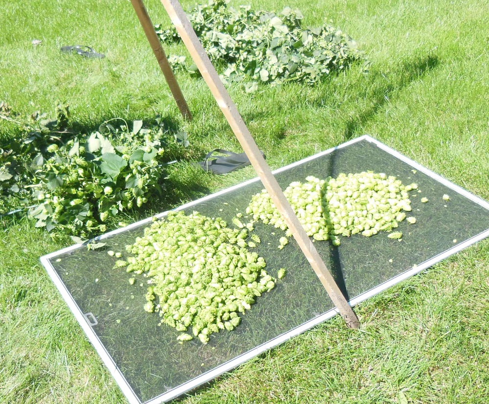
Since they had grown so high, I cut all four bines about 6 feet up and lowered the upper section to the ground as you can see in this photo. I picked the cones off the remaining 6 feet and will let that part of the plant continue to grow until it naturally stops this fall. This should strengthen the root system so I can cut it back and then have it come back with vigor in the spring.

 The next 60 to 90 minutes were pretty easy and monotonous, just plucking cones off the bines. The old window screen worked well to collect the cones and it was fun to watch my small piles slowly grow as my hands got slightly sticky from the hop oils and my arms itched from the hop fibers. They say to wear gloves and protective clothes, but I'm a noob this year.
I finally finished with two piles of cones, the bare bines in the compost bin, and a successful harvest. The funny thing is that a batch of beer uses somewhere around 4 oz. of hops - once these 2 pounds are dry, that's just about how much I'll have. A summer of growing for just one batch of home brew.
But, it was sooooo fun, entertaining, interesting, and educational to grow my own, and next year they should produce about twice as much. I'll have a better trellis to keep the hops separated and they will be more mature with a higher yield.
Oh, and I did hike 5 miles on the trail this morning before harvest!
08/29/2016
Stickers in the Wild

 I really enjoyed meeting so many people on the Superior Hiking Trail last week. I handed out a few Hiking Dude stickers, and got a couple of new pictures for my sticker page.
 If you've got one of my stickers on your water bottle, pack, car bumper, or whatever, send me a pic of it in the wild and I'll add it to the page.
If you want a sticker, either run into me on the trail or click here.
08/25/2016
Day 6 - Ending at Tettegouche
 I walked 40368 steps on the trail today.
I traveled about 14 miles today.
After the nice time in camp last night, I slept well and woke to a clear sunrise for yet another great day of hiking, avoiding the rain that was expected.
Our route took us from the backwoods with lakes towards the UPs and Downs of the hills by Superior. We only met 1 lady and then 2 boy scouts on the trail - a quiet day.
About an hour into the hike, Martin's knee started complaining.
We crossed a cool beaver dam and then climbed up the Section 13 area with great views all around. From there, it was up and down along a ridge line all the way to the Baptism River and Tettegouche State Park. We had wonderful breezes off the big lake most of the day and the trail was good. But, with a knee continuing to get worse, we decided that 84 miles was a nice hike for this week and there was no need to go farther.
I was very happy with the part of the trail we traveled. It included a broad range of terrain and different north woods environs. A bear or moose, or even deer, would have been nice, but squirrels, loons, swans, snakes, frogs, toads, mushrooms, tiny fishes, and crayfish were all interesting to see.
If you check out our path ( Check out my current location on the map. ) you can see the tracker did not do very well in the woods - I'm quite disappointed about that and will be letting the company know.
One more thing, Tettegouche has a new, very nice visitor center - if you get up the north shore, you really should stop in.
Leave Comment
Posted: 08/25/2016
Posted: 08/25/2016
08/24/2016
Day 5 - Lake Country
 I walked 31769 steps on the trail today.
I traveled about 13 miles today.
Our hike was relatively flat compared to previous days. The trail traversed the high boggy area on the back side of the sawtooth mountains that ride from Lake Superior's shore. We crossed over low hills between lakes Sonju and Egge, and many boggy areas along the way. The lakes are beautiful, with swans and loons cruising about. The 4 campsites on these two lakes are nice too. We met Sean, Casey, and Steven at a site when we took a morning break. They wound up at the Leskinen Creek site with us tonight. When we arrived here, Pat and Katie were already here. So, it was a nice evening visiting with new friends and enjoying a small campfire. I would really recommend this section of trail for someone that wants a weekend taste of the SHT - mellow trail, lakes, and nice sites. Concerns of bad weather proved unnecessary as it was quite warm, then cloudy, but now a nice breeze and less humidity tonight. I hope it stays. Food has been good and adequate, water filters working great, and just minor physical pains. We've been very fortunate to meet a wide range of people, all out enjoying Minnesota in their way.
Leave Comment
Posted: 08/24/2016
Posted: 08/24/2016
08/23/2016
Day 4 - Free Beer
 I walked 39597 steps on the trail today.
I traveled about 15.8 miles today.
It seems each day is getting harder than the last. The trail was steeper and rockier, the weather was hotter and more humid, and the muscles and joints complained more. But, it was still a great day of hiking! We hiked from Dyers Creek, crossed the Caribou River, climbed up, over, and across the very hot, south facing Horseshoe Ridge, plummeted down to the Manitou River, and finally climbed up to Aspen Knob for the night. The trail was empty until we reached Crosby-Manitou park. We had just been talking about having a beer when we get home, and wondering about the weather forecast, when we saw two young guys camping by the trail. We stopped to chat and asked if they had heard any weather news. They then offered us beer. Not to be rude, we accepted and had a nice talk with Zach and Ryan, two working actors on a quick camping trip. An hour or so later, we got to our campsite and set up. Four college friends showed up so we got to visit with them this evening. They have been on the trail 11 days and want me to call them the poopy boys - so there you go.
Leave Comment
Posted: 08/23/2016
Posted: 08/23/2016
08/22/2016
Day 3 - Sun, Rivers, and Bugs
 I walked 38302 steps on the trail today.
I traveled about 15.7 miles today.
Another beautiful day for hiking but this one had late summer humidity and the mosquitos finally tracked is down. I got a handful of bites this afternoon. We crossed the Temperance and Cross rivers, handfuls of creeks and uncountable mud holes. We only ran into a few hikers and none seemed to be too interested in chatting. We have the campsite at Dyers Creek to ourselves tonight. The creek is full of small fish and crayfish. We had lots of time to relax in camp and had a fire for the third night on a row. Carlton Peak had great views of Lake Superior and the rivers were nice scenery.
Leave Comment
Posted: 08/22/2016
Posted: 08/22/2016
Older Posts Newer Posts
Find more Hiking Resources at www.HikingDude.com


Follow Me
Recent Comments